 NERC Data Catalogue Service
data.gov.uk (non-INSPIRE)
Type of resources
Available actions
Topics
Keywords
Contact for the resource
Provided by
Years
Formats
Representation types
Update frequencies
Service types
Scale
Resolution
-

Scanned collection of seismological journals and offprints. The original collection was compiled by John Wartnaby. John Wartnaby was a curator at the Science Museum, London, and wrote a historical survey of seismology and scientific instruments. His accumulated papers consist chiefly of offprints and articles, and many older British Association seismological reports. The collection is part of the National Seismological Archive.
-
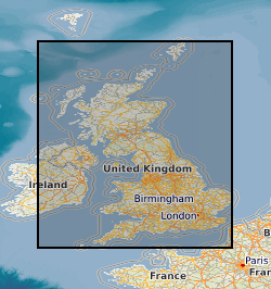
The 5km Hex GS Landslides dataset shows a generalised view of the GeoSure Landslides v8 dataset to a hexagonal grid resolution of 64.95km coverage area (side length of 5km). This dataset indicates areas of potential ground movement in a helpful and user-friendly format. The rating is based on a highest level of susceptibility identified within that Hex area: Low (1), Moderate (2), Significant (3). Areas of localised significant rating are also indicated. The summarising process via spatial statistics at this scale may lead to under or over estimation of the extent of a hazard. The supporting GeoSure reports can help inform planning decisions and indicate causes of subsidence. The methodology is based on the BGS Digital Map (DiGMapGB-50) and expert knowledge of the behaviour of the formations so defined. This dataset provides an assessment of slope instability. Landslide hazard occurs due to particular slope characteristics (such as geology, gradient, sources of water, drainage, man-made constructions) combining to cause the slope to become unstable. Downslope movement of materials, such as a landslide or rockfall may lead to a loss of support and damage to buildings. Complete Great Britain national coverage is available.
-
These files contain ground penetrating radar (GPR) data collected from the glacier margins and forelands of Falljökull and of Kvíárjökull, south-east Iceland, between 2012 and 2014. The data were collected using a Sensors and Software PulseEKKO Pro GPR system. For each glacier the data are stored in folders that indicate the month and year in which the surveys were conducted. Each GPR profile has a Sensors and Software GPR (.DT1) file, and associated header (.HD) and GPS (.GPS) files. The .HD files (which can be opened as text files) give the parameters and equipment used for each profile. GPS files are not available for some of the profiles collected on Falljökull in April 2013 (due to damage that occurred to the GPS linked with the PulseEKKO Pro system). For these profiles start, finish, and mid profile positions were recorded using differential GPS, and locations of these profiles are instead given by GIS shapefiles in the relevant folders. These datasets have been used in the publications listed below. Further information relating to the data collection methodology can be found therein. Phillips, Emrys; Everest, Jez; Evans, David J.A.; Finlayson, Andrew; Ewertowski, Marek; Guild, Ailsa; Jones, Lee. 2017 Concentrated, ‘pulsed’ axial glacier flow: structural glaciological evidence from Kvíárjökull in SE Iceland. Earth Surface Processes and Landforms, 42 (13). 1901-1922. https://doi.org/10.1002/esp.4145 Phillips, Emrys; Finlayson, Andrew; Bradwell, Tom; Everest, Jez; Jones, Lee. 2014 Structural evolution triggers a dynamic reduction in active glacier length during rapid retreat: evidence from Falljökull, SE Iceland. Journal of Geophysical Research: Earth Surface, 119 (10). 2194-2208. https://doi.org/10.1002/2014JF003165 Phillips, Emrys; Finlayson, Andrew; Jones, Lee. 2013 Fracturing, block-faulting and moulin development associated with progressive collapse and retreat of a polar maritime glacier: Virkisjokul-Falljokull, SE Iceland. Journal of Geophysical Research: Earth Surface, 118 (3). 1545-1561. https://doi.org/10.1002/jgrf.20116 Flett, Verity; Maurice, Louise; Finlayson, Andrew; Black, Andrew; MacDonald, Alan; Everest, Jez; Kirkbride, Martin. 2017. Meltwater flow through a rapidly deglaciating glacier and foreland catchment system: Virkisjökull, SE Iceland. Hydrology Research, 48 (6). 1666-1681. https://doi.org/10.2166/nh.2017.205
-
This dataset shows the variation of the thickness of Superficial (Quaternary age) deposits across Great Britain. The data are presented as a vector map of interlocking hexagon cells (side length 1km, area c.2.6 Km2) covering the landmass of Great Britain as a regular grid. Each hexagon cell is attributed with a series of statistics about the thickness of the underlying Quaternary units (e.g. average); additional information relating to the thickness models and the coverage of underpinning data is provided. The data is all derived by spatially summarising the information originally created for the high-resolution Superficial Deposit Thickness Model (a 50m cell size raster model of thickness, first published in 2010).
-

High frequency (100 Hz) data from two horizontal induction coils measuring the Earth's magnetic field at the Eskdalemuir Observatory in the United Kingdom. The data covers the period from January 2019 to December 2019. Also included are examples of Matlab code and the frequency calibration files to convert to the raw data to SI units. Thumbnail spectrograms and metadata are also supplied.
-
3D laser surface scan of a fossil held within the BGS Type and Stratigraphical Reference Collection. Sample number: BGS GSM 37292 Species: Metrolytoceras metretum (Ammonite) Age: Inferior Oolite Group, Jurassic Location: near Sherborne, Dorset
-
Manuscript geological maps produced by the Survey geologists or other recognised geologists on County Series (1:10560) and National Grid (1:10560 & 1:10000) Ordnance Survey base maps of Great Britain. A small number are produced at larger scale. Similar maps compiled from other sources. Maps produced since the 1850's, current holdings over 35,000 maps, all now scanned and available internally as image files.
-
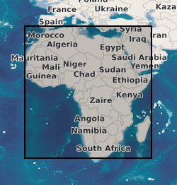
A geographic information system (GIS) containing geo-data for the energy transition across continental Africa created by extracting data from open sources into a series of shapefiles and rasters containing information on culture, geology, geothermal and geophysical data. This data is stored in the World Geodetic System (WGS) 1984 Geographic Projection System.
-
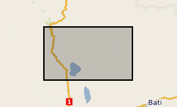
In 1998 the Department for International Development (DFID) funded the project ‘Groundwater drought early warning for vulnerable areas’ as part of the DFID Knowledge and Research (KaR) programme, a collaboration between UK partners BGS and the Overseas Development Institute (ODI), and with the Bureau of Water, Mines and Energy in Amhara Region, Ethiopia. Drawing on village surveys and stakeholder consultations across sectors, this project evolved a broader, more holistic approach to the study of drought and water supply. Rather than focus exclusively on drought and water availability, constraints on household access to and use of water were explored through the lens of water security. This, in turn, highlighted links between the household water economy (across seasons; between good and bad years) and wider livelihood strategies, particularly in relation to inter-dependencies between food and water security.
-

Scanned images of seismic phase data sheets containing phase readings, phase arrival times, amplitude data, magnitude data and derived source information like hypocentres (locations), fault plane solutions etc for earthquakes recorded by BGS seismic stations. The data is in the format used by the location program HYPO71 (Lee & Lahr, 1975) which was the most used program for local earthquakes.